|
|
|
What is Imaging Laser Altimetry
Laser altimetry is a fully automatic method of directly measuring
the height or elevation of the terrain from an aircraft or a satellite.
Imaging laser altimetry provides digital three-dimensional information
about the shape of the Earth's surface. It is also referred to
as 'Airborne Laser Mapping', 'LIDAR mapping' or 'Airborne Laserscanning'. The instruments used to perform these measurements are called
‘laser altimeters‘ or 'laserscanners'. Today the most advanced
laser altimeters are additionally able to determine the vertical
surface structure and the height of objects on the ground like
trees, bushes, or buildings, plus surface brightness.
Imaging laser altimetry competes with two other methods to obtain
3D topographic data: stereo-photogrammetry and airborne SAR (Synthetic
Aperture Radar) Interferometry.
Imaging Laser Altimetry being a direct measurement method generating
three-dimensional measurements right away it requires the least
manual or interactive effort for data processing of all of the
automatic or semi-automatic methods named above.
Each of these methods simplifies the formerly expensive and tedious
process of surface elevation surveying significantly. Whereas
for instance several hundred square kilometers of terrain elevation
can be collected in one day using an airborne laser altimeter
and the time to process the resulting data into a digital surface
model may take a similar amoutnt of time, groundbased survey teams
would need weeks to months, depending on the terrain accessibility
to collect the data. Data entry and processing would likely also
need rather weeks than days to finish the product.
Although GeoLas Consulting specializes on Imaging Laser Altimetry
we will help you find the method to get 3D data best suited for
your application.
|
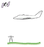 |
How does a laser altimeter work
A laser altimeter is operated from a plane, a helicopter or a
satellite. It determines the distance to the Earth's surface by
measuring the time-of-flight of a short flash of infrared laser
radiation. The instrument emits laser pulses which travel to the
surface, where they are reflected. Part of the reflected radiation
returns to the laser altimeter, is detected, and stops a time
counter which was started when the pulse was sent out. The distance
is then easily calculated by taking the speed of light into consideration.
In order to figure out the exact geographic 3D coordinates (latitude,
longitude, elevation) of any surface spot that was hit by a laser
pulse it is necessary to know two more items in addition to the
distance: the location of the aircraft from which the measurement
was made, and the direction in which the laser altimeter was ‘looking‘.
These values are usually obtained through GPS-receivers (for the satellite-based Global Positioning System) in the aircraft
and, for reference, on a known location on the ground, and an
INS (Inertial Navigation System) onboard the aircraft. With a laser
altimeter system composed of these components the absolute coordinates
of surface spots can be determined with vertical and horizontal
errors of less than 10 cm (4") and 20 cm (10"), respectively.
|
|
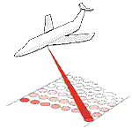
3D mapping and imaging
Up to today laser altimeters can only do one range measurement
at a time. In order to create a three-dimensional map or image
of the Earth's surface, between 2000 and 400000 range measurements
per second are performed, each to a different spot on the surface.
To effect this the laser beam is scanned on a line across the
direction in which the aircraft is flying. From one line to the
next the aircraft moves forward thus measuring to spots on a different
line during the next scan. This way strips of surface elevation
values are gathered. Depending on the laser altimeter used and
the altitude of operation above ground spot sizes of 20 cm (8")
to 25 m (85 ft) and strip widths of 50 m (150 ft) to 9 km (6 mi)
can be achieved.
If the laser altimeter is able to measure the intensity of the
returning laser pulse in addition to its round-trip time-of-flight,
an image of the surface reflectance at the laser wavelength may
be generated. This image is automatically co-registered with the
elevation map.
|
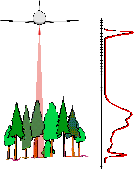 |
Advanced techniques: Waveform digitization
In the lastest LIDAR systems a new technique to retrieve more
information about the vertical surface structure is now available:
waveform digitization.
Instead of just measuring the time-of-flight of the laser pulse
until its first or last echo arrives ("discrete returns"), as
in conventional mapping LIDAR systems, a waveform LIDAR samples
the return signal very rapidly and store the entire echo waveform.
Sampling frequencies of 1 GHz (one billion samples per second)
are typically used, yielding an echo profile with a sample spacing
of only 15 cm.
The advantage of this approach is that the vertical structure
of the surface can be derived with high accuracy. For example,
the echo waveform of every single emitted laser pulse holds information
about the density of a tree canopy at different heights, the height
and density of understorey vegetation, and even about surface
slope and roughness.
With these detailled "insights" into the vertial structure of
forests more detailled modells of biomass, timber volume, or vegetation
health can be made. Information about surface roughness and slope
can help with more accurate surface type classification and modelling.
Furthermore, even information about the surface reflectance at
different height levels can be extracted - the color of a roof
at the laser wavelength can be differentiated from the color of
the ground within a single lidar waveform measurement. With conventional
systems most of this information is lost.
Last but not least, in contrast to conventional discrete return
LIDAR systems a waveform-digitizing LIDAR is able to discerne
targets very close to each other within each laser shot. Conventional
systems are blind for typically 2-3 meters after each detected
return, so ground returns below lower vegetation may not be detected
reliably.
|
|
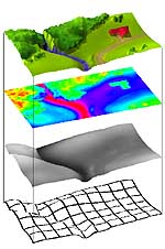
Generating surface models, digital landscapes and 3D images
Usually a site is covered by several partially overlapping strips
of elevation data. They are merged to generate a digital image
or model of the surface elevation.
A digital image is a rectangular array of cells where each cell
contains one value. For a normal image the cells contain brightness values, in the case of an elevation image they, of course, contain
elevation values. While the surface spots in the original elevation data
are usually not spaced evenly, the cells of the image all have
the same size and are regularly spaced to facilitate processing.
The digital elevation model (DEM) is a continuous mathematical representation describing the shape
of the surface where elevation is a function of longitude and
latitude. Two types of DEMs are useful: the digital surface model (DSM) which contains elevation values of the Earth's surface as it
is. It includes surfaces of all objects on the ground like buildings
and trees. The DSM can be generated directly from laser altimeter
data. The other type is the digital terrain model (DTM). It is derived from the DSM by applying filtering functions which
remove surface objects. It reflects the pure terrain elevation
the way terrain elevation is given in topographic maps.
Digital landscapes may be considered as digital surface models with additional information
like surface color and texture or vegetation types to allow a
more realistic representation than the other, purely geometrical
models above.
Both digital elevation images and digital elevation models are
2 1/2-dimensional representations of the Earth's surface. Both
can be used to render orthogonal (birds-eye) views and oblique
(perspective) views of the surface. In general, most of the processing
of elevation data will however be done based on an image-like
format.
They are considered 2 1/2-D representations of reality because
for every location on the surface only one elevation value is
given. In reality, however, there may be several surfaces with
different elevation values at the same location: a bridge has
a top surface, and another surface is below the bridge; a tree
has many surface levels in its canopy, and ground is at yet another
level, but all of these surfaces are above the same location.
Therefore, a truly three-dimensional representation, image or
model must support several vertical levels at any location. Also,
rendering realistic, oblique views from any perspective requires
true 3D data as your viewpoint may allow you to see 'under' the
bridge.
The following paragraph shows how Imaging Laser Altimeters can
- to some extent - actually provide truly three-dimensional information
|
|
Thematic mapping and visualization
The information contained in each laser pulse echo is not just
limited to one surface elevation value. Using advanced signal
detection and processing techniques each shot yields information
about the vertical structure of the surface (roughness, height
and shape of objects, canopy density and height of trees, etc.)
and the reflectivity of the surface (similar to infrared aerial
photography). This additional information is useful for a variety
of analyses and to generate ‘thematic’ models of the surface.
Thematic models may, for example, represent vegetation density,
tree heights, or the ratio of sealed surfaces (asphalt, concrete)
versus porous surfaces (sand, dirt, vegetation) on the surface.
For visualization purposes information related to surface roughness
can be used to apply realistic texture. Information about vegetation
(height, density etc.) may serve to create ‘transparent‘ forests
or as input to software designed to render realistic trees.
The usual approach in commercial systems to combine surface brightness
information with surface geometry is, however, to use a high-resolution
digital camera in parallel with the laser altimeter. This has
the advantage of usually providing a higher resolution for the
image than a laser altimeter could offer, and it is possible to
register in several spectral bands (i.e. in color). On the other
hand, a separate camera needs illumination whereas the laser altimeter
as an active system works both day and night. Also, the camera
images will contain shadows of surface objects, making automatic
object recognition based on brightness or color very difficult.
The laser reflectance image is free of shadows and can be calibrated
to give the precise surface reflectance at the wavelength of the
laser.
The combination of scanning laser altimeter with multispectral
and/or thermal scanners and digital photogrammetric cameras represents
an approach to automate a number of remote sensing tasks, which
in the past afforded significant manual effort to gather, process,
merge and analyze the data.
|
|
3D City models and GIS
3D city models can be considered an example for the next level of abstraction
in processing output from imaging laser altimetry. DSMs reflect
elevation at any individual surface point but they do not contain
direct information about the objects on the surface. Elevation information of groups of DSM cells can, however, be readily used to discriminate between
surface objects and ground and to derive some of the surface object
characteristics. In the case of 3D city models the surface objects
of interest are, of course, buildings. In the simplest case a
3D city model approximates each building by a rectangular block
with the base dimensions, orientation and the height of the building.
Laser altimetry is able to produce DSMs of urban areas with planimetric
resolutions in the order of 0.5 - 2 m (2-6 ft). This is sufficient
to reconstruct the heights, footprints and even the approximate
roof shapes of the vast majority of buildings.
Similary, other parameters required as input for Geographic Information Systems (GIS) can efficiently be obtained using imaging laser altimetry. A
GIS is essentially a digital database of spatial information that
can hold a wide spectrum of topographic, geologic, hydrologic,
infrastructural, demoscopic, administrative and other data. It
is organized in a way that facilitates access, retrieval, and
display of the data through the specification of geographic locations.
Being a fully digital tool for 3D surveying imaging laser altimetry
can directly feed elevation and object height information layers
of a GIS by supplying digital geolocated 3D data.
|
|
For examples of where digital landscapes and DSMs are useful proceed
to our Applications page:
|
|
|
|